`Remember me on this computer` option
Select the `Remember me on this computer` option if you wish to be automatically logged on to the computer in future. Your account will remain active for 45 days. Please do not use the `Remember me` option if using a computer with public access or that is used by more than one person.
Seller information

Sold and shipped by
Return of order


View more related products to:
HUMMINBIRD AUTOCHART
Leave no waters uncharted.
roprietary software from the new Humminbird AutoChart uses your Humminbird’s sonar returns and GPS to build your charts
Simply record that information onto the AutoChart Zero Lines map card (included), import that data into the AutoChart PC program which will convert it into a lake map.
Once complete, transfer your new custom map back onto the AutoChart Zero Lines map card and it’s ready to display on any compatible Humminbird.
No subscriptions.
No hidden fees.
No need to submit your data and wait weeks for a finished chart.
AutoChart does it instantly - and your data is kept private, so your competition is none the wiser.
*Optional for select ONIX, ION, 1100, 900, 800, 600 and 300 Series models.
3 STEPS:
RECORD SURVEY DATA
Travel back and forth then up and down water in a zig-zag pattern with your Humminbird in record mode.
CONVERT YOUR DATA
Transfer the saved survey data from your Humminbird to your PC via the AutoChart Zero Lines map card (included). AutoChart will convert that data into a detailed map.
EXPORT YOUR MAP
Save the newly created map back onto your AutoChart Zero Lines map card for use in your Humminbird.
ZERO LINES MAP CARD
The Zero Line is the place where the water meets the shore.
Humminbird AutoChart includes a map card loaded with Zero Lines for millions of water bodies.
With these all-important Zero Lines as your foundation, you can begin creating your own accurate and detailed maps of any fishing spot.
The Zero Line map card is also formatted to record your sonar logs
After recording, load the card into your computer to let the AutoChart PC Software convert the recordings into a map that can be displayed on your compatible Humminbird.
DVD PC SOFTWARE
The AutoChart DVD software for your PC is the powerful engine used to turn survey data into a sophisticated lake map.
The map created by the AutoChart software can be viewed on the computer AND be exported back to the Zero Lines map card to be viewed on you compatible Humminbird unit.
Now you can have your own map for that secret honey hole and keep it a secret.
AMAZING DETAIL
With AutoCharts generated contours, youll have access to all the detail and features of Humminbird LakeMaster® charts including:
- Depth Highlight (Depth Highlight Range)
- Water Level Offset
- Shallow Water Highlight
- Mark, Import, and Export waypoints
- i-Pilot Link
3D VIEWS
When viewing your AutoChart maps on your PC you will be able to see the underwater world in revolutionary 3D detail to give you a better understanding of what the structure looks like on your favorite lakes.
FOLLOW THE CONTOUR
With i-Pilot Links innovative Follow the Contour feature, it directs the trolling motor to follow a specific depth contour.
The chosen contour line can be automatically followed in either direction, or stay a set distance from it or the shoreline using the Contour Offset feature.
I-PILOT LINK IN ACTION
This screen shot shows a contour selected and i-Pilot Link automatically guiding the boat along its course.
This incredible feature is now available on what was once previously unmapped water- when data is surveyed and converted using AutoChart.
AUTOCHART PRO
Add another layer of detail to your AutoChart cartography.
New AutoChart PRO offers all the leading features of AutoChart - but with two key enhancements designed to give tournament anglers a competitive edge. Bottom Hardness Indication delivers a crucial tip-off to where fish are hiding, while Side Imaging Mosaic allows you to overlay your Side Imaging returns onto your AutoChart map for a 3D visualization of fish-holding habitat.
With AutoChart PRO, youll have all the tools necessary to bring your next trophy in sight.
BOTTOM HARDNESS INDICATION
Identify areas likely to hold fish based on the hardness of the bottom. Exclusive to AutoChart PRO.
SIDE IMAGING MOSAIC
Overlay Side Imaging returns onto your map for a 3D visualization of contours. Exclusive to AutoChart PRO.
The SPANISH AREAS be recorded according to the division of MTN50 (Additional photo or attached link).
http://www.humminbird.es/uploads/1/4/2/3/14231779/cuadricula_mtn50.png
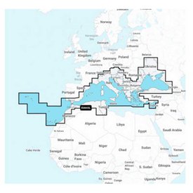
Autochart Pro works by zones, wach continent needs a different product. This is European Version.
LANGUAGES
English
German
Spanish
French
Italian
Swedish
Benefit from our offers for Humminbird Autochart Pro Europe Map. In our online nautical and fishing store, at waveinn we have the best products so that you can enjoy your activities without complications and with the best nautical and fishing equipment. You also can visit other nautical and fishing categories and find products of the brand Humminbird at the best price.
Write a review about this product and earn CoINNs 
Write a review about this product
Tradeinn Retail Services as the data controller will process your data in order to respond to your query or request. You can access, rectify and delete your data, as well as exercise other rights by consulting the additional and detailed information on data protection in our Privacy Policy.

30-DAY
EASY & FAST RETURN

SECURE & SAFE
SHOPPING

SATISFACTION
100% GUARANTEED

LOWEST PRICES
GUARANTEED
Related products
Close
ABOUT waveinn

SHOP WITH CONFIDENCE
CUSTOMER SERVICES
4.6 / 5


By Verified Reviews
OUR TRIATHLON CLUB

DOWNLOAD OUR APP


Follow us on


Departments
Top Brands


Copyright 2009 - 2024 by waveinn. TRADEINN RETAIL SERVICES, S.L. CIF/VAT ES-B-17527524, C/ Pirineus, 9, 17460 Celrà (Girona), Spain. Terms & Conditions | Affiliate programs | Cookies policy | Privacy policy | Legal notice | Privacy policy social networks


 Returns
 Help & Contact
 Shops
Shops


 Other sports


 Legal information


 Pay in 3 interest-free instalments.